Jánošíkove Diery - Grand Circuit
- 05:25
- 12.5 km
- 650 m
Until recently, the climb up to the Martinské hole ski resort was not especially appealing. That changed with the opening of a new route through the Pivovarský potok valley. Near the top, it turns into a via ferrata with scrambling sections in a narrow canyon, alongside cascades and waterfalls, and even across rope bridges.
From the final bus stop at the Martin, Stráne (500 m) junction, an information board points you onto the asphalt road to the left. The route is waymarked in red, which you will follow through several small intersections and past cottages scattered through the forest. After about ten minutes, a meadow and a few new houses appear on your right. Just beyond them, continue straight through a junction and within moments you will enter a valley with the stream on your left.
The path crosses the stony streambed several times from one bank to the other, and about half a kilometre from the start of the valley it brings you to remains of former mining activity — a stone crusher, mine carts, and even remnants of rails with a switch.
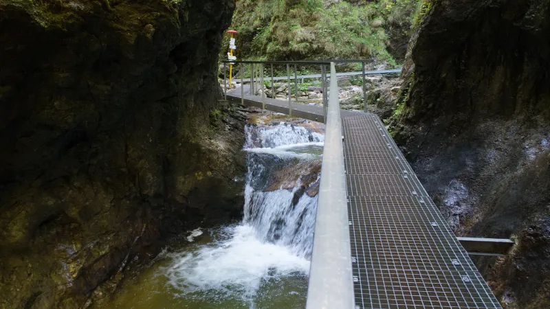
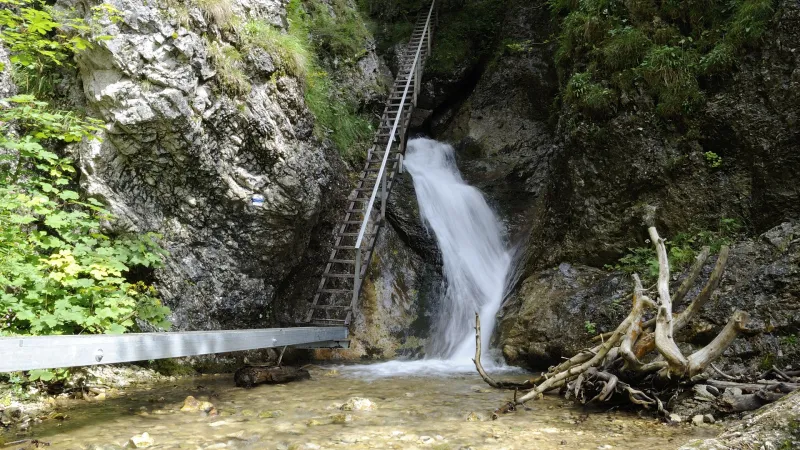
About half a kilometre farther on, the valley briefly opens up, and after another kilometre you cross a logging track to reach the start of the second part of the ascent through the valley. This section is much steeper and more demanding, and you will already need to use your hands while climbing. Here the stream has carved a narrow canyon full of cascades and waterfalls. For safe passage through this section, you should have a helmet and climbing harness and clip into the steel cables with a via ferrata set along the difficult stretches.
As you make your way up the ferrata, there will be no shortage of exciting moments. At one point you can choose a short, harder alternative that crosses the gorge via two rope bridges. After about an hour of climbing through the gorge, the route splits into an easier option on the left (similar in difficulty to what you have already climbed) and a harder option on the right, which is steeper, slightly longer, but also more scenic. If you go right, this section will take about half an hour to complete; then the route turns left away from the stream and after a hundred metres reaches the point where the path from the easier option joins from the left. If you choose the easier option, you will arrive here a few minutes sooner. At this spot you can share your experience by signing the summit logbook. The via ferrata is graded B, with a harder C alternative at the end. The necessary equipment can be rented from Lacný Skialp in Vrútky.
Continue on the red-marked trail, which soon bends sharply right and before long emerges onto a wide blue-marked track at the Bazová (1,245 m) junction. Turn right, pass a small waterworks building, and after the second bend you will already see the first cottages of Martinské hole, the local hiking and ski resort.
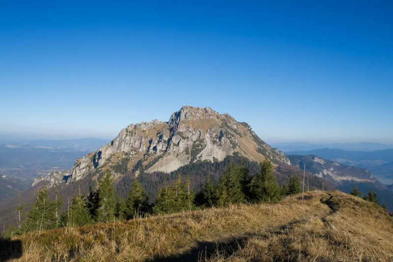
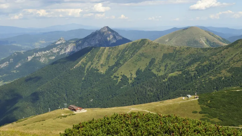
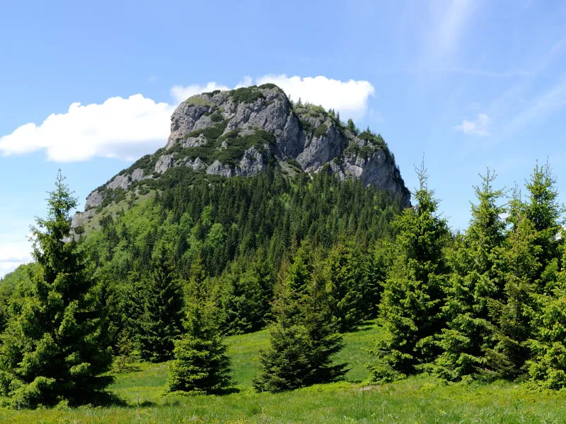
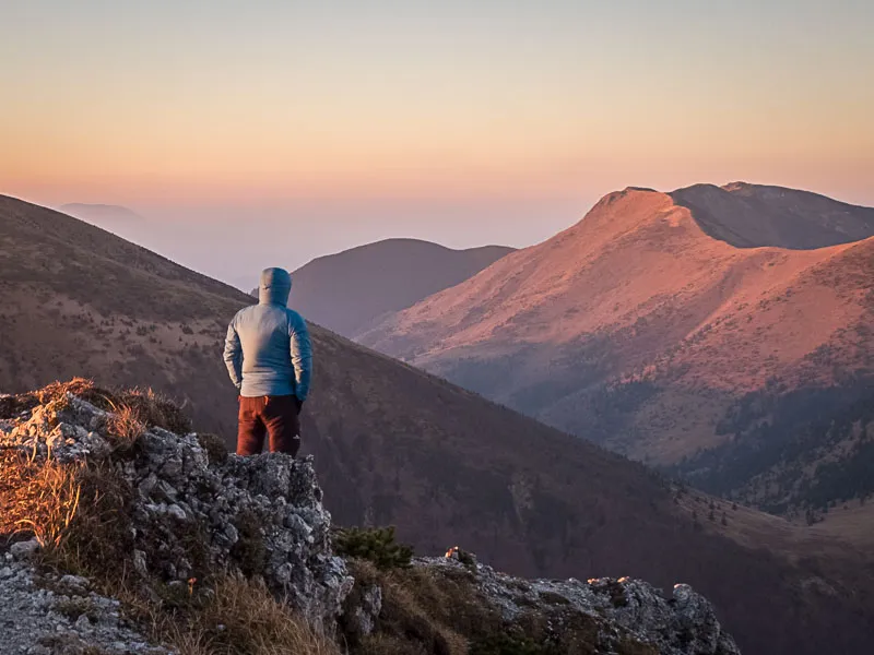
After a few minutes you cross a ski slope and reach the Martinské hole, chaty (1,250 m) junction near the Martinské hole mountain hut. From here continue left on the yellow trail along an asphalt road. Right at the start, the road curves sharply left at the edge of another ski slope and climbs gently to the Krížava (1,457 m) junction below a tall transmitter. Turn sharply left onto the red-marked path, and from there it is only about 15 minutes to the smaller transmitter on the highest summit of the Lúčanská Malá Fatra — Veľká lúka (1,476 m). The trail is almost flat at first, with only a short steep climb near the end.
From the summit you can see the town of Martin and the surrounding villages below, the Krivánska Malá Fatra, the opposite Veľká Fatra, and the Strážov Mountains on the other side. In good visibility you can also spot Veľký Choč and the ridges of the Western Tatras and the Low Tatras.
From Veľká lúka, return the same way to the Martinské hole mountain hut. Here you can stop for refreshments and rest after the climb. To head back to Martin, you can start from the nearby junction on the yellow trail, which follows an asphalt road for the first few kilometres and later the switchbacks of the old road that was once used to drive up to Martinské hole. However, this route is rather long and fairly dull. A better option is to take the shortcuts used by locals, which are clearly worn in.
When you step out in front of the hut, go left to the edge of the car park. Below you, you will see a worn footpath crossing a wider track. Take the footpath, cross the track, and continue descending gently on the well-trodden path. After eighty metres you cross another wider track, followed by a short steep descent curving slightly left. After a few more dozen metres, turn right into the forest onto a wide worn path. Follow it for about five hundred metres until it emerges at the junction of a broad track and the asphalt road marked yellow. Continue left on the road. In the second left-hand bend, at the Pod Kalužnou (1,053 m) junction, the yellow trail leaves sharply right onto the old road. Follow it for a few metres until you see a worn path descending on the left. This is the first of several shortcuts cutting across the many switchbacks of the old road.
Whether you stay on the marked route or use the shortcuts, you will reach the Hodinovka (855 m) junction, where there is a memorial in the form of a cannon. From here, at the end of the war, partisans shelled the fascist army in the area around Martin. Continue on the marked path or the shortcuts farther down until you reach cottages scattered through the forest.
From there it is only a few minutes’ walk to the bridge over the stream. It lies near the lower station of the former cable car to Martinské hole, where the asphalt road to Martin also begins. Follow it downhill and after about ten minutes you will return to the final bus stop and parking area at the Martin, Stráne (500 m) junction.