To Ďumbier by the Back Way
- 06:45
- 18 km
- 1320 m
Crossing the Low Tatras is an unforgettable 100-kilometre backpacking journey, with options to sleep in mountain huts and shelters or in a tent or under the stars at designated campsites. Let’s look at the more attractive western section of the ridge trail.
The traverse of the Low Tatras usually starts in Donovaly, which lies on the main road linking Ružomberok and Banská Bystrica, so bus access is excellent. Right from Donovaly (960 m), follow the red trail marker, which will lead you along almost the entire ridge route.
The route begins on a gently climbing paved road, passing several hotels. As you gain elevation, increasingly good views open up behind you towards Zvolen and the ridge of Veľká Fatra with its summit Krížna. The road leads to the small settlement of Polianka, where the asphalt ends and a forest track begins. In the woods, flatter stretches alternate with occasional climbs until you reach the grassy saddle below Kečka. On the right stands a small cabin, and a short way beyond it you can refill water from a spring.
After the saddle, a short climb through beech forest leads to the broad grassy summit of Kečka (1,225 m), where the first larger panorama opens up, dominated by the massive bulk of Prašivá. A path along the grassy ridge skirts Handliarka (1,208 m) and descends to Hadlanka saddle. After this easy-going section, your legs will get a workout on the climb to Kozí chrbát (1,330 m), followed shortly by a descent to Hiadelské sedlo.
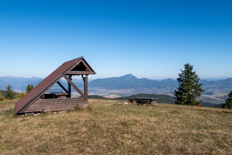
At Hiadelské sedlo (1,099 m) you’ll find a fairly new shelter where camping is allowed, and a little lower down there is also a spring. It would be a lovely spot if not for the high-voltage pylons that spoil the setting and hum unpleasantly in the wind. In fact, this saddle is where the Low Tatras ridge really begins – the section you’ve walked so far still belongs to the Starohorské vrchy.
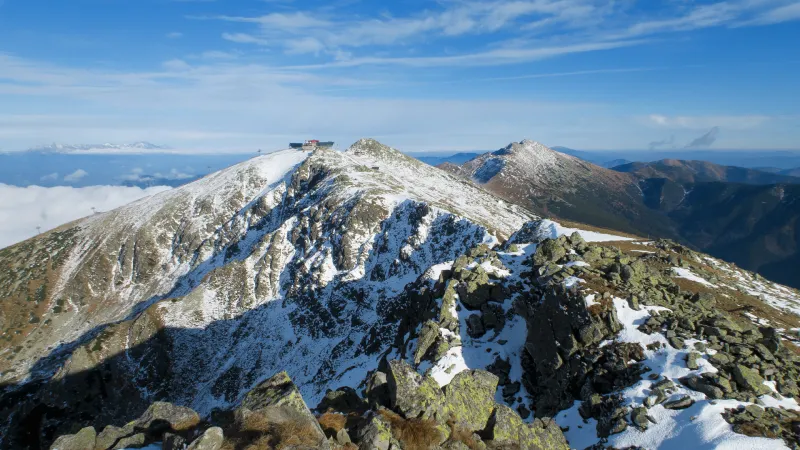
Beyond the saddle comes one of the longest climbs of the entire ridge traverse. First through forest, later through dense dwarf pine, you gain nearly 600 vertical metres to the summit of Prašivá (1,673 m). Fortunately, this demanding ascent is the last of its kind for quite a while. Over the next kilometres, no other climb will take more than a few dozen minutes.
From Prašivá, the path leads via Malá Chochuľa (1,719 m) to neighbouring Veľká Chochuľa (1,753 m), then gradually descends to Košarisko (1,693 m) and the junction Košarisko, sedlo (1,670 m). A steeper descent follows, and by contouring below the ridge through occasional patches of dwarf pine you arrive at the broad grassy saddle pod Skalkou (1,476 m). The trail also contours around Veľká hoľa (1,540 m) before climbing to Latiborská hoľa (1,648 m).
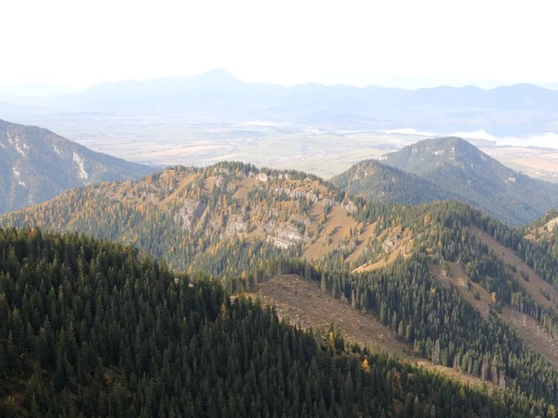
In clear weather, Latiborská hoľa offers superb views of the summits ahead and back along the ridge, as well as Malá Fatra, Veľká Fatra, the Western Tatras, and in the distance even the High Tatras. You may also spot Veľký Choč and Orava’s iconic peak, Babia hora. Similar views accompany you for almost the entire Low Tatras traverse.
After descending to sedlo Latiborskej hole (1,540 m), an easy stretch follows across Zámostská hoľa (1,630 m), after which a climb of about 150 vertical metres warms you up again on the way to Ďurková (1,751 m). In the saddle beyond Ďurková, an unmarked path branches right to the shelter below Chabenec (1,630 m), better known simply as Ďurková.
A little farther on, a green-marked trail also turns off the ridge to the shelter. But that way is a detour and includes unnecessary elevation gain to the junction, which you then immediately lose again, so most hikers use the unmarked shortcut instead.
At the shelter you can not only spend the night, but also choose something from a limited food menu and refill water from a strong spring a short distance from the hut. Sleeping capacity is limited (around 30 people in a shared sleeping room), so it’s worth arriving early. When it’s full, people also sleep in the dining room. It’s also possible to camp in your own tent around the shelter.
From Ďurková, climb back to the ridge on the blue trail, rejoin the red trail, and continue ascending to Chabenec (1,955 m). From the shelter it’s about 300 vertical metres, so if you were cold in the morning, you probably won’t be here. Beyond Chabenec comes a short steep descent followed by a fairly easy walk to Kotliská (1,937 m), where a massive spur branches south from the main ridge towards Skalka (1,980 m). The red trail, however, descends to Križské sedlo (1,775 m) and continues across Poľana (1,889 m) to sedlo Poľany (1,827 m). Here it meets a yellow trail coming up from the biggest resort area in the Low Tatras – Demänovská Valley. This means the previously quieter ridge section now gives way to the busiest part of the range. A short distance beyond the saddle begins a stone-paved path leading around the summit of Dereše (2,004 m) below Chopok.
At Chopok, things get genuinely busy – hikers stream in from both sides of the ridge, and those who don’t want to, or can’t, walk up arrive by cable car. A few metres below the upper station stands the rebuilt and modernised Kamenná chata pod Chopkom, offering food, shelter from bad weather, and accommodation. Right behind the hut, the path climbs to the summit of Chopok (2,024 m), which from here looks like little more than a big pile of rocks and a short winding path. Regardless of the crowds, the views are beautiful, and Ďumbier looks especially majestic from here.
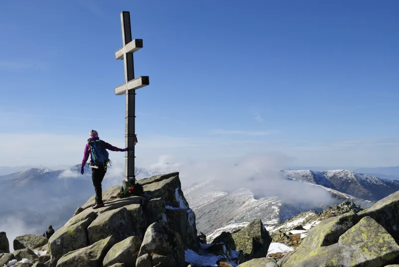
From the hut, the paved path continues on, contouring across Chopok’s southern slopes and descending just below the ridge to Demänovské sedlo (1,756 m). Beyond the saddle, prepare for 300 vertical metres of climbing via Krúpovo sedlo (1,925 m) to Ďumbier (2,046 m). Ďumbier is the highest peak in the entire range, and from the summit cross you can once again admire the long wall of the Western Tatras and the High Tatras. During a Low Tatras traverse, it’s a view you’ll see often, but it never gets old.
The top of Ďumbier is reached only by a short detour from the ridge route, so you need to return to Krúpovo sedlo and only then continue on the red trail to M. R. Štefánik Hut (1,740 m) – locally known as “Štefánička” – the destination of today’s stage.
M. R. Štefánik Hut is one of the larger mountain huts, so you can stay in one of its six 8-bed rooms. After several days on the trail, a shower will certainly be welcome too. Beds can be booked in advance, and as always it’s best to reserve as early as possible. More info and reservations at www.chatamrs.sk.
The final stage is relatively short and there are several options. If you continue along the Low Tatras ridge trail, stay on the red trail via the junction Králička (1,682 m) and Kumštové sedlo (1,549 m), over Rovienky (1,602 m), and finally descend to Čertovica saddle (1,238 m). From there, the red trail continues into the eastern part of the Low Tatras towards Kráľova hoľa (1,946 m), which is why this section is also known as the Kráľovohoľské Tatras.
Bus service from Čertovica is poor, so if you plan to leave the ridge today, it’s better to descend from the Králička junction on the yellow trail via Bocianske sedlo (1,506 m) into the Starobocianska valley, following it all the way to the road from Čertovica at the junction Starobocianska dolina – ústie (956 m). Here, turn left onto the main road and after 300 metres turn right onto a smaller road leading to the village of Vyšná Boca (950 m). From there it is much easier to catch a bus, for example to Liptovský Hrádok and onward to Liptovský Mikuláš, where all trains on the Bratislava–Košice line stop.
Take the train to Ružomberok and change to a bus to Donovaly. The bus station is directly opposite the railway station.
Return: descend to the village of Vyšná Boca, where buses run to Liptovský Hrádok, from where you can easily continue to Liptovský Mikuláš. All trains stop there.
DAY 1
Donovaly - Vrchlúka (0:20) - Hiadelské sedlo (3:00) - Veľká Chochuľa (5:15) - Latiborská hoľa (7:30) - sedlo Ďurkovej (9:30) - shelter below Chabenec (9:45)
DAY 2
shelter below Chabenec - Chabenec (1:00) - Kotliská (1:45) - Poľana (2:30) - Chopok (4:00) - Demänovské sedlo (4:45) - Krúpovo sedlo (5:10) - Ďumbier (5:40) - Krúpovo sedlo (6:00) - M. R. Štefánik Hut (6:40)
DAY 3
M. R. Štefánik Hut - Králička (0:30) - Kumštové sedlo (1:10) - Čertovica (2:25)
Day 1
Day 2
Day 3